Visiting the magnificent coasts of New Brunswick and Prince Edward Island creates anxiety for many families worried about the powerful tides and crumbling cliffs. The secret to a safe and awe-inspiring visit isn’t just checking a tide chart; it’s about learning to read the coast’s natural rhythm. This guide moves beyond simple rules to explain the underlying mechanics of the tides and erosion, transforming your caution into confident respect for one of Earth’s greatest natural spectacles.
The pull of the moon on the Bay of Fundy is a tangible thing. You can feel it in the air as you stand on the coastline, watching the water retreat for kilometers, exposing a temporary world on the ocean floor. For families, the promise of walking where ocean giants will swim just hours later is an irresistible call to adventure. Yet, this magic is shadowed by a valid concern: stories of stranded hikers and collapsing cliffs are as much a part of local lore as the tides themselves. The fundamental fear is that in this powerful place, a simple mistake could have serious consequences.
Most guides will offer the usual advice: check the tide times, keep a safe distance from the cliffs. While true, this is like telling a sailor to “watch the wind” without teaching them how to read a squall line. The real key to safety lies in a deeper understanding. It’s about recognizing the subtle signs of an undercut cliff on PEI’s red shores, knowing why the tide’s return is fastest when it seems furthest away, and appreciating the geological story that makes one cliff a fortress and another a fragile sculpture.
But what if the key to safety wasn’t a checklist of fears, but a lesson in listening? What if you could learn to read the tidal rhythm and the geological pulse of the coast? This guide is built on that principle. We will not just tell you the rules; we will explain the ‘why’ behind them. By understanding the forces at play, you can move from anxiety to awe, and give your family an experience that is not only safe, but profoundly connected to the raw power of Canada’s East Coast.
This article will guide you through the specific dangers and beauties of different Maritime coastlines, teaching you how to interpret the environment like a local guide. From the eroding shores of PEI to the working wharves of Nova Scotia, you’ll gain the confidence to explore safely.
Summary: Safely Navigating the Tides and Cliffs of the Maritimes
- Why are the cliffs of PEI retreating by meters every year?
- How to explore the St. Martins sea caves before the tide turns?
- PEI National Park or New Brunswick coast: which offers better cliffside views?
- The selfie mistake near the edge that local authorities warn against
- When to arrive to see the full transformation from island to pillar?
- The tide table mistake that traps hikers on the beach
- Why was this specific cliff chosen as the key to controlling the St. Lawrence River?
- How to experience a working fishing wharf in Nova Scotia without getting in the way?
Why are the cliffs of PEI retreating by meters every year?
The iconic red cliffs of Prince Edward Island are not static landmarks; they are in a constant, dramatic state of retreat. This is not a slow, gentle process. While the average loss is around 30 centimeters per year, some areas can see up to 5 meters disappear in a single storm event, as witnessed during Hurricane Fiona. The reason lies in their very composition: soft sandstone. This material, while beautiful, is incredibly vulnerable to the relentless action of waves and weather.
The primary danger for any visitor is the phenomenon of undercutting. Waves carve out the base of the cliff, leaving an overhang that appears stable from above. This creates a treacherous illusion of solid ground that can suddenly give way under a person’s weight. The geological pulse of this erosion is visible to the trained eye. You can learn to read the warning signs that the land itself provides.

As the image shows, the texture of the cliff tells a story of instability. Look for scalloping patterns at the base, which indicate active wave erosion. Fresh soil, vegetation debris on the beach below, or damaged plant life at the edge are all clear signals of a recent collapse. The root systems of plants are critical for holding the soft earth together, and their absence is a major red flag. Respecting these natural warnings is the first principle of safety on PEI’s shores.
How to explore the St. Martins sea caves before the tide turns?
The St. Martins sea caves offer a thrilling opportunity to step inside the architecture of the Bay of Fundy. At low tide, they are explorable caverns carved into the cliffs. At high tide, they are completely submerged, with water levels rising up to 38 feet (11.5 meters). The transformation happens every six hours, turning a walkable beach into a deep-water channel. Navigating this change requires a precise understanding of the tidal rhythm, not just a casual glance at a chart.
The common mistake is assuming you have until the exact moment of low tide to explore. The key is to work within a specific window of opportunity. The safest strategy is to begin your exploration about one hour before the officially published low tide. This is when the water has receded enough to grant access. The water remains low for approximately two hours in total, meaning you must plan to be out of the caves within one hour *after* the official low tide mark. This gives you a total safe exploration window of about two hours.
Inside the caves, the environment demands respect. The rocks are covered in sharp barnacles, making sturdy water shoes with good grip and even dive gloves a wise precaution. More importantly, you must remain constantly aware of the incoming tide. It can move deceptively fast, cutting off your exit path around a bend before you realize it. Always keep your exit in sight and monitor the water’s edge. The powerful forces that carved these caves are still at work, and respecting their schedule is non-negotiable for a safe return.
PEI National Park or New Brunswick coast: which offers better cliffside views?
When comparing the cliffside views of PEI National Park and the New Brunswick Fundy coast, the question isn’t just about beauty, but about the very different safety philosophies and geological realities of each location. While both offer stunning vistas, the way you experience them is shaped by infrastructure and the nature of the rock itself.
PEI’s cliffs are predominantly soft sandstone, making them highly unstable and prone to unpredictable undercutting. In response, Parks Canada has implemented strict access controls and robust safety infrastructure. In contrast, New Brunswick’s Fundy coast features harder conglomerate rock, but it is prone to massive, sudden calving events like the collapse of Elephant Rock. The safety measures can be more variable depending on the specific location. The following table highlights these crucial differences.
This comparative analysis from Parks Canada’s guidelines and other observations shows two distinct approaches to managing coastal risks.
| Safety Feature | PEI National Park | New Brunswick Fundy Coast |
|---|---|---|
| Cliff Access Control | Superintendent’s closure areas with $150 minimum fines for trespassing | Variable – some areas unrestricted |
| Safety Infrastructure | Designated lookoffs like Oceanview with safe viewing platforms | Mix of engineered viewpoints and natural edges |
| Erosion Rate | 0.28 meters per year average | Sudden collapses like Elephant Rock (100-200 tonnes) |
| Warning Systems | Fences, ropes, signage including poison ivy warnings | No staff when park closed, safety barriers may be removed |
| Rock Composition | Soft sandstone, unstable and unpredictable with undercuts | Harder conglomerate but prone to massive calving events |
As Parks Canada emphasizes for its jurisdiction, the principles of conservation and safety are paramount. In their own words:
These safety and conservation principles apply to any sandstone cliffs across PEI National Park
– Parks Canada, PEI National Park Sandstone Cliffs Conservation Guidelines
Ultimately, PEI National Park offers a more curated and controlled viewing experience with engineered safety, while the New Brunswick coast can offer a wilder, more direct connection to the landscape, but with a greater onus on personal responsibility and awareness.
The selfie mistake near the edge that local authorities warn against
In the age of social media, the drive to capture the perfect, dramatic photo has introduced a new and tragic risk to coastal exploration. Standing near a cliff edge, back to the view, focused on a screen, is a recipe for disaster. This “perceptual drift”—where the mind prioritizes the digital image over the physical reality of a crumbling precipice—is a global phenomenon. It’s not a baseless fear; research shows over 379 selfie-related deaths worldwide between 2008 and 2021, a number that starkly overshadows fatalities from shark attacks.
On the coasts of New Brunswick and PEI, this danger is magnified. The soft sandstone of PEI can collapse without warning, and even the harder rock of the Fundy coast is not immune to sudden failure. Local authorities and park staff repeatedly warn visitors that there is no such thing as a “safe” edge. The very ground that seems solid could be an unsupported overhang, weakened by the last storm or the tide’s relentless work.
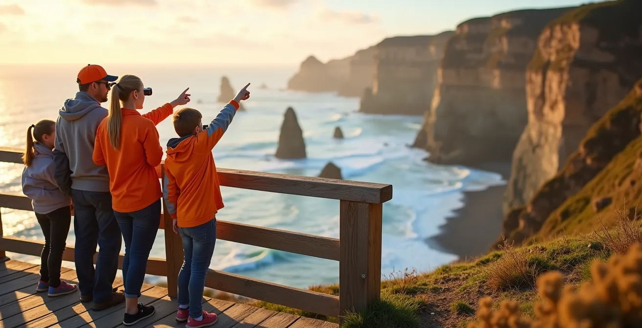
The solution is to consciously separate the act of photography from the act of positioning. The safest way to enjoy and capture the view is from designated platforms and viewpoints. These structures are engineered for safety, set back a considerable distance from the unstable edge. As seen in the image, they allow for unobstructed views and great photo opportunities without ever putting you or your family at risk. By using these facilities, you are not compromising your experience; you are ensuring you will be around to share the memories you capture.
When to arrive to see the full transformation from island to pillar?
Witnessing the full power of the Hopewell Rocks transformation—from towering islands in a vast bay to pillars you can walk around—is the ultimate Bay of Fundy experience. The tidal range here is among the world’s highest, with the Bay of Fundy’s extreme tides reaching 16 metres (52 feet). To see both extremes, high and low tide, requires a strategic approach, not just a single visit. It’s about timing your arrival to the rhythm of the six-hour tidal clock.
The most effective strategy is to plan for a “double feature.” Many tickets, like those for the Hopewell Rocks Provincial Park, are valid for two consecutive days, specifically to allow for this. The goal is to maximize your time on the ocean floor during low tide and then return to see the same spot completely submerged. The ocean floor is typically accessible for a six-hour window: from three hours before low tide to three hours after. To get the most out of it, arrive about two hours before the published low tide. This allows you to follow the water as it recedes and gives you ample time for exploration.
A smart itinerary involves scheduling your visit around these two key moments. You might spend the morning walking the ocean floor, then have lunch at an on-site restaurant or explore the upper trails while waiting for the tide to turn. Returning to the viewing platforms three to four hours after low tide provides a stunningly dramatic view of the water rushing back in to reclaim the land. This carefully planned “double feature” ensures you don’t just see the tides; you experience the profound and powerful transformation they create.
Your Strategic Itinerary for Hopewell Rocks
- Utilize 2-day ticket validity to see both high and low tides on consecutive days or in one long day.
- Arrive 2 hours before the published low tide to follow the water out and maximize your time on the ocean floor.
- Plan your walk within the safe 6-hour window (3 hours before to 3 hours after low tide).
- Exit the ocean floor well before the mid-cycle point, when the incoming water rises at its fastest rate.
- Return to the upper viewing platforms 3-4 hours after low tide to witness the dramatic high tide views.
The tide table mistake that traps hikers on the beach
The single most dangerous mistake visitors make in the Bay of Fundy is a fundamental misinterpretation of the tide table. Many people see the published time for low tide and assume the water will magically start rising at that exact moment. The reality of the tidal rhythm is far more complex and hazardous. The tide does not operate like a switch; it flows like a sine curve.
This means the water level changes very slowly around the points of high and low tide, but it moves fastest during the middle of the cycle. The critical danger lies in the three hours equidistant between high and low tide. This is when the largest volume of water is moving. Hikers, feeling a false sense of security because the water is far out, can be caught completely off guard by the speed of its return. A generic weather app on a phone often lacks this crucial local context, making official, on-site tide charts the only reliable source of information.
To counter this perceptual drift and ensure your family’s safety, a disciplined approach is necessary. Don’t rely on one person’s memory or a single phone. Implement a buddy system with clear protocols. Set multiple alarms, designate a timekeeper, and build in a significant safety buffer. The goal is not to leave at the last minute, but to be heading back long before the tide’s return accelerates. This conscious discipline is the only effective countermeasure to the tide’s deceptive rhythm.
Action Plan: Tide Safety Buddy System
- Point of Contact: Immediately upon beach arrival, set two separate “turn-around” alarms on different devices (e.g., two phones).
- Collecte: Use only the official on-site tide charts. Photograph it. Note the low tide time and calculate your “must-leave” time (e.g., 1 hour after low tide).
- Cohérence: Cross-reference your alarms. One person is the primary timekeeper, responsible for verbal warnings. A second person is the backup.
- Mémorabilité/Émotion: Program alarms for 30 minutes *before* your turn-around time, not at the time itself. The sound should be an unignorable signal to start walking back immediately.
- Plan d’intégration: Establish clear verbal check-ins every 20 minutes to confirm time and position relative to your exit path.
Why was this specific cliff chosen as the key to controlling the St. Lawrence River?
To understand the danger of the Maritime’s eroding cliffs, it’s incredibly useful to look at a contrasting example: Cap Diamant, the great cliff upon which Quebec City is built. Its selection by military engineers centuries ago was no accident; it was a masterclass in reading geology for strategic advantage. This historical lesson has direct relevance to modern tourist safety.
The key difference is rock composition and stability. Unlike the soft, erosion-prone sandstone of PEI or even the conglomerate rock of Hopewell, which can break off in huge sections, Cap Diamant is made of much harder, more durable rock. It has undergone immense pressure and change, making it a stable foundation. This durability made it the perfect, unbreachable anchor for a fortress controlling the narrowest point of the St. Lawrence River. Early engineers were, in effect, conducting sophisticated geological stability assessments, a skill that is just as vital for today’s coastal explorers.
The contrast is stark: one cliff is chosen to build a permanent city upon, while others are so fragile they retreat by meters each year. This highlights a critical safety principle: not all cliffs are created equal. The beautiful, sculpted formations of the Bay of Fundy are a product of their instability. Their beauty is inseparable from their inherent danger. Recognizing this allows you to approach them with the proper respect and caution they demand, understanding that you are visiting a dynamic, ever-changing environment, not a static monument.
Key Takeaways
- The Bay of Fundy’s tides follow a “sine curve,” moving fastest in the middle of the cycle, not at the turn of the tide.
- PEI’s red sandstone cliffs are actively eroding and dangerously undercut; always observe from designated safe platforms.
- Safe exploration of sea caves requires a strict time window, typically starting one hour before low tide and ending one hour after.
How to experience a working fishing wharf in Nova Scotia without getting in the way?
A visit to a working fishing wharf in a place like Lunenburg or Digby offers an authentic glimpse into the heart of Nova Scotia’s maritime culture. However, these are active, industrial worksites, not tourist attractions. For a safe and respectful visit, it’s crucial to distinguish them from tourist-ready wharves like Peggy’s Cove and understand the rhythm of their daily operations.
The primary rule is to avoid the critical operational hours. Early morning, typically from 4 AM to 7 AM, is a flurry of activity as crews bait traps and boats depart. This is the worst time for a casual visitor. The best time to visit is often in the late afternoon, between 3 PM and 5 PM. During this window, you can often see the fleet returning and unloading their catch, providing plenty of activity to observe without impeding crucial work.
Safety on a wharf is a matter of constant vigilance. There are numerous “invisible” dangers for the uninitiated. High-tension mooring lines can snap with incredible force. Forklifts move quickly and have large, unpredictable turning radiuses. Areas near processing stations are often slippery with organic waste. And perhaps most importantly, even on a calm day, the edges of breakwalls can be struck by sudden, powerful rogue waves. By keeping a respectful distance, staying aware of your surroundings, and observing the unwritten rules of these workplaces, you can enjoy the experience without becoming a hazard to yourself or the hardworking crews.
Now that you can read the rhythms of the coast, the final step is to apply this knowledge with a deep and abiding respect for its power. Plan your visit not as a conquest, but as a conversation with one of the world’s most dynamic landscapes.
Frequently Asked Questions about Working Wharf Safety
What are the invisible dangers on a working Canadian wharf?
High-tension mooring lines under extreme stress, unmarked forklift routes, slippery fish processing waste, and sudden rogue waves near breakwalls pose serious risks to unaware visitors.
When is the best time to visit without disrupting operations?
Late afternoon (3-5 PM) when boats return and unload provides activity while avoiding critical early morning preparation and departure times.
How can tourists identify worker-only zones?
Look for yellow safety lines, restricted access signs, active loading equipment, and areas with workers in high-visibility gear – these indicate operational zones to avoid.