Contrary to popular belief, conquering the West Coast Trail isn’t about having the most expensive gear, but about mastering the coast’s unforgiving rhythm.
- The real challenges are the pervasive damp that defeats gear and the tide schedule that dictates your survival, not just the mud.
- Success requires a mindset shift: you must learn to think like the coast, reading its signs and respecting its power.
Recommendation: Prioritize learning to read a tide chart and implementing a triple-layer waterproofing system over simply upgrading your boots or jacket.
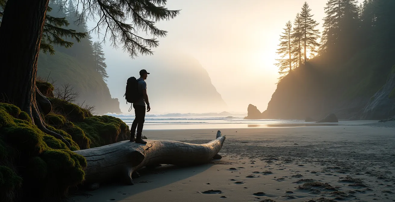
The West Coast Trail. For any serious hiker, the name alone conjures images of epic ladders, misty forests, and the wild, untamed edge of Vancouver Island. It’s a bucket-list trek, a rite of passage carved into the Pacific coastline. Most guides will give you the standard advice: get good boots, pack a rain jacket, be ready for the mud. And while that’s not wrong, it’s dangerously incomplete. It’s the kind of advice that gets people into trouble, focusing on the gear you carry rather than the knowledge you need in your head.
I’ve walked this coast for decades, seen the tides trap the unprepared and the relentless damp turn a $1000 tent into a cold, wet sack. The truth is, the trail’s greatest challenges aren’t the ones you can see. They are the invisible forces: the pull of the ocean, the pervasive humidity that seeps into everything, and the ancient rules of the temperate rainforest. This guide is built on a different philosophy. It’s not just about surviving the 75 kilometers from Pachena Bay to Gordon River. It’s about learning to understand and move with the coastal rhythm. We’ll go beyond generic gear lists to focus on the specific skills and mindset that distinguish a successful thru-hike from a miserable—or even dangerous—one.
For those who prefer a visual format, the following video offers a stunning immersion into the landscapes and challenges that define this iconic Canadian trail, perfectly complementing the practical advice in this guide.
This article is structured to build your expertise from the ground up. We’ll cover everything from the unique wildlife and essential waterproofing techniques to the critical skill of tide-proofing your hike, ensuring you are prepared not just physically, but mentally, for the challenge ahead.
Summary: Mastering the Rhythms of the West Coast Trail
- Why is the Spirit Bear only found in this specific coastal region?
- How to waterproof your gear effectively for 5 days of relentless rain?
- Pacific Rim or Northern BC: which rainforest experience fits your skill level?
- The tide table mistake that traps hikers on the beach
- How to spot coastal wolves in the brush without disturbing them?
- How to build a survival kit for a 3-day hike in the Yukon?
- Accessible boardwalks or remote boat access: which rainforest trip fits your budget?
- How to explore Cathedral Grove responsibly without damaging the ancient root systems?
Why is the Spirit Bear only found in this specific coastal region?
Let’s clear the air and a common misconception right away. You won’t find the iconic Spirit Bear (Kermode bear) on the West Coast Trail. Their territory is much further north, primarily in the Great Bear Rainforest. However, the trail passes through a region with its own unique and powerful apex predator: the coastal sea wolf. These are not your typical grey wolves. They are a genetically distinct population that has adapted to a life dictated by the ocean’s rhythm. Their presence is a testament to the rich, interconnected ecosystem you’re about to enter.
The West Coast Trail passes through the traditional territory of the Pacheedaht, Ditidaht, Huu-ay-aht, and Nuu-chah-nulth peoples, who have inhabited this area for thousands of years. As Parks Canada notes in its official guide, these nations have maintained a deep, respectful relationship with the *Ma’iitq* (wolf).
The West Coast Trail passes through the traditional territory of the Pacheedaht, Ditidaht, Huu-ay-aht peoples, who have maintained a respectful relationship with the Ma’iitq (wolf) for thousands of years
– Parks Canada, West Coast Trail Information Guide
Case Study: The Marine Diet of Coastal Wolves
Research from institutions like the University of Victoria has shown that these wolves have a diet that can consist of up to 90% marine-based food. Instead of primarily hunting deer, they patrol the shoreline, scavenging on whale carcasses and hunting for salmon, seals, and even barnacles. This deep connection to the ocean is what makes them a uniquely coastal creature and a powerful symbol of the Pacific Rim.
Understanding this is your first step to “thinking like the coast.” The animals here are tied to the tides and the seasons just as you will be. Respecting their home means understanding their habits and giving them the space they command. Spotting one is a rare privilege, a sign that you are truly in a wild place.
How to waterproof your gear effectively for 5 days of relentless rain?
On the West Coast, rain is a given. But the real enemy isn’t the downpour; it’s the pervasive damp. This is the constant, seeping humidity that gets into everything, day and night. Condensation inside your tent, dampness in your “dry” clothes—this is what leads to misery and hypothermia. A simple pack cover isn’t enough. You need to adopt a redundant, multi-layered system designed to fight moisture from both the inside and the outside.
The goal is to create a series of barriers, assuming each one might fail. Your sleeping bag and a change of clothes are your survival gear; their dryness is non-negotiable. This means creating a virtually impregnable core within your pack while treating the pack itself as a disposable outer layer. This macro shot shows the goal: water beading perfectly, unable to penetrate the fabric—a state you must maintain for all critical gear.
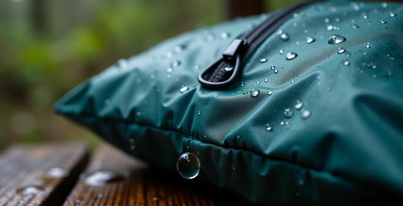
As you can see, every element, from the coated fabric to the sealed seams, works together. This system-based thinking is key. The following audit checklist is not just a list of items; it’s a process you should follow every single morning on the trail to ensure a dry, safe night’s sleep.
Your Action Plan: The Triple-Layer Waterproofing Audit
- Core Defense: Is your primary pack liner (a thick compactor bag is best) completely sealed with no holes?
- Internal Compartments: Are critical items (sleeping bag, electronics, clothes) each inside their own dedicated, sealed dry sack within the main liner?
- Sacrificial Layer: Is your external pack cover properly fitted and secured to take the brunt of the rain?
- Contamination Control: Are all wet items (rain-soaked jacket, muddy gaiters) stored in a separate, designated “wet” stuff sack outside your primary liner system?
- Daily Maintenance: Have you used a microfiber towel to wipe down all condensation from the inside of your tent before packing it away?
Embracing this methodical approach is the single most important thing you can do to ensure your comfort and safety. Treat every drop of water as an intruder and your waterproofing system as your fortress.
Pacific Rim or Northern BC: which rainforest experience fits your skill level?
The call of British Columbia’s rainforests is strong, but not all coastal hikes are created equal. The West Coast Trail (WCT), located in the Pacific Rim National Park Reserve, is an iconic and demanding trek. However, it exists within a system of maintained infrastructure. Further north, the North Coast Trail offers a fundamentally different experience: true, unsupported wilderness. Choosing the right trail for your skill level, expectations, and tolerance for risk is a critical first step in planning.
The WCT is a logistical challenge that requires meticulous planning and a reservation, but it provides a safety net. With over 100 ladders, numerous cable cars, and First Nations Trail Guardians on the ground, help is structured. While evacuations happen, the vast majority succeed; approximately 98-99% of hikers complete the trail. The North Coast Trail, by contrast, is for the truly self-reliant explorer who craves solitude and is prepared for raw, unmanaged terrain.
This decision often comes down to a simple question: are you a “Planner-Achiever” seeking to conquer a world-famous challenge, or a “Self-Reliant Explorer” looking for solitude at any cost? The following table breaks down the key differences to help you make an informed choice.
This comparative analysis highlights the trade-offs between a structured-but-crowded iconic trail and a solitary-but-riskier wilderness route.
| Feature | West Coast Trail | North Coast Trail |
|---|---|---|
| Difficulty | Challenging but with infrastructure | Expert-level, true wilderness |
| Trail Infrastructure | 100+ ladders, cable cars, bridges | Minimal – rope assists, basic markers |
| Permits | Mandatory reservation system | Self-registration, no quota |
| Evacuations/Year | 60-80 hikers | Data not available |
| Indigenous Presence | Active First Nations Guardians | Traditional territories, less active presence |
| Best For | Planner-Achievers seeking iconic challenges | Self-Reliant Explorers craving solitude |
| Trail Traffic | Up to 75 hikers/day | Often solo or small groups |
Ultimately, an honest assessment of your skills, your comfort with isolation, and what you truly seek from the experience will guide you to the right path. The WCT is an incredible achievement, but it’s just one of many ways to experience the magic of BC’s coast.
The tide table mistake that traps hikers on the beach
This is the most important skill you will learn. More than your physical fitness, more than your gear, your ability to read and interpret a tide table will dictate your safety on the West Coast Trail. The ocean is not just scenery; it’s a non-negotiable deadline. Many coastal sections are beautiful, walkable beaches at low tide and deadly, impassable surge channels at high tide. Making a mistake in your calculations doesn’t just mean a delay; it can mean being trapped by a rising ocean against an unclimbable cliff.
The most common mistake is a simple one: using the wrong tide table or misinterpreting the time. The official Canadian Hydrographic Service tables are your bible, but you must use the Tofino table and correctly adjust for Pacific Daylight Time. As this hiker demonstrates, a moment of careful study on the rocks is a life-saving investment. You must cross-reference the tide height in metres with the impassable sections marked on your Parks Canada map.
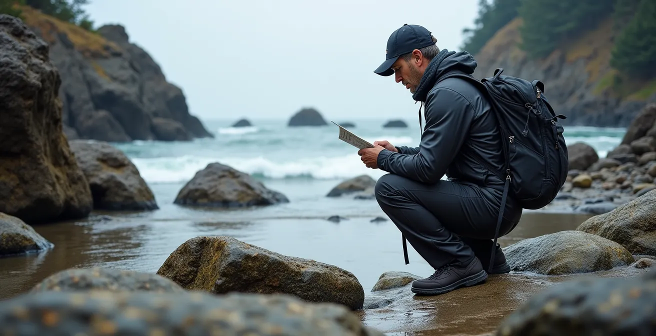
For example, a section might be impassable above 2.7 metres. You need to know not just when low tide is, but the exact time the water will reach that 2.7m mark on its way back up. This requires a simple calculation but is often overlooked.
Case Study: The Owen Point Calculation
The notorious Owen Point is a prime example. It’s a scramble over slippery boulders and through surge channels, and the point itself is only passable at tides below 1.8m, so using the wrong table would be extremely dangerous. Imagine you arrive at 3:00 PM. Low tide was 1.2m at noon, and the next high tide is 2.4m at 6:00 PM. The rate of rise is 0.2m per hour. By 3:00 PM, the tide is already at 1.8m and rising fast. This is a classic “do not pass” scenario. Attempting it would mean racing a rising tide through one of the trail’s most hazardous sections.
Always build in a safety buffer. The ocean is powerful and unpredictable; storm surges can add a metre to the predicted height. Your schedule is not your own out here. It belongs to the moon and the pull of the sea.
How to spot coastal wolves in the brush without disturbing them?
Seeing a coastal wolf is the highlight of a lifetime for many hikers, a profound reminder that you are a guest in an ancient, wild world. But this privilege comes with a deep responsibility. The goal is not to “find” a wolf, but to learn to read the landscape for their signs and, if you are lucky, to observe them from a safe and respectful distance without ever altering their behaviour. Disturbing them, even unintentionally, can have serious consequences for both wolf and human safety.
The key is to use your eyes and your wits, not your feet. Wolves are creatures of habit and efficiency. They use the same travel corridors you do: the hard-packed sand at the tide line and the game trails that weave from the beach into the forest. The best time for sightings is often early morning or late evening, when the beach is quiet. Instead of searching for the animal itself, search for the evidence it leaves behind.
Here are the signs to look for, as detailed in this comprehensive West Coast Trail hiking guide:
- Tracks: Check the wet sand at the tide line, especially during early morning low tides. Wolf prints are larger and more oval-shaped than a dog’s, with the outer toes often splayed.
- Scat: Look for droppings near creek mouths and on prominent points. Wolves use scat to mark their territory, and freshwater sources are key marking spots.
- Game Trails: Notice the subtle paths leading from the beach into the dense salal brush. These are the highways for all forest creatures, including wolves.
- Ravens: Pay attention to the birds. A congregation of ravens often indicates a carcass, a major food source that will attract predators and scavengers.
If you are fortunate enough to see a wolf, the rule is absolute: maintain a minimum distance of 100 meters. Use binoculars or a telephoto lens. Never, ever approach them, make loud noises, or try to get their attention. Simply stop, be still, and witness. Your presence should be a ghost on the landscape—unfelt and unnoticed. That is the true mark of a respectful wilderness traveler.
How to build a survival kit for a 3-day hike in the Yukon?
I get asked about survival kits for all sorts of environments, from the dry cold of the Yukon to the deserts of the Southwest. But let me be clear: a coastal rainforest survival kit is a different beast entirely. In the Yukon, you fight the cold. On the West Coast, you fight the wet and the isolation. Here, cell service is non-existent. A sprained ankle isn’t a limp back to the car; it’s a serious incident requiring outside intervention. And that intervention often comes from the sea or the air.
Your standard “ten essentials” are just the starting point. For the WCT, your survival kit must be tailored to the specific realities of a marine environment with zero infrastructure. Every year, 60 to 80 hikers per season are evacuated from the trail, and it’s your preparedness that makes the difference between a successful rescue and a tragedy. Your kit needs to address three core challenges: communication, hypothermia, and the potential for a water-based evacuation.
This isn’t about packing for “what if.” It’s about packing for “when.” An injury or gear failure is a very real possibility, and your add-on kit is your insurance policy. Below is the mandatory coastal survival add-on that every hiker should carry in addition to their standard first-aid supplies.
- Satellite Messenger: An InReach or Zoleo is not optional; it is mandatory. It’s your only reliable link to the outside world.
- Marine VHF Radio: Many evacuations are conducted by the Coast Guard via boat. A VHF radio can be a critical communication tool in these scenarios.
- Redundant Fire Kit: Assume your lighter will fail. Carry a ferro rod, stormproof matches, and waterproof tinder (like waxed jute) in a sealed container.
- Emergency Bivvy: Lightweight and compact, an emergency bivvy sack is the most effective way to prevent hypothermia while waiting for rescue.
- Water Purification Tablets: Your filter can clog or break. Tablets are a foolproof backup.
- Extra Rations: Pack at least two extra days’ worth of high-calorie, no-cook emergency food.
This kit isn’t about thriving; it’s about surviving an unplanned night or two while you wait for help. It’s about respecting the trail’s remoteness and taking responsibility for your own safety in a place where you are truly on your own.
Accessible boardwalks or remote boat access: which rainforest trip fits your budget?
Experiencing the grandeur of the Pacific Rim’s rainforest doesn’t have to mean committing to the epic 7-day ordeal of the West Coast Trail. There are multiple ways to immerse yourself in this ancient ecosystem, each with a different price tag, time commitment, and physical demand. Understanding these options allows you to tailor an experience that fits your budget and your adventure style, from a simple two-hour stroll to a guided marine expedition.
The total cost can be around $410.25 for a typical hiker on the full WCT, which includes permits, ferry fees, and park entry before you even account for gear and transportation to the trailhead. It’s a significant investment of both time and money. At the other end of the spectrum, the Rainforest Trail near Tofino offers an incredible taste of the old-growth forest on accessible boardwalks for the cost of a daily park pass. For those seeking a middle ground, a zodiac tour of the Broken Group Islands provides a unique marine perspective on the rainforest, guided by experts who can bring the ecosystem to life.
Each option delivers a different “Return on Investment.” Is your goal the lifetime achievement of the WCT, universal access for the whole family, or a unique, educational perspective from the water? The following table breaks down the approximate costs and benefits of three distinct Pacific Rim experiences.
| Experience | Duration | Total Cost (CAD) | What’s Included | Return on Investment |
|---|---|---|---|---|
| The Epic: Full West Coast Trail | 7 days | $410.25/person | Permits, ferry fees, park entry | Lifetime achievement, bragging rights |
| The Accessible: Rainforest Trail Boardwalks | 1-2 hours | $11/adult daily | Park entry, parking | Universal access to ancient giants |
| The Marine: Broken Group Islands Zodiac | Half day | $150-200/person | Guide, boat, interpretation | Unique marine rainforest perspective |
There is no “best” option—only the one that is best for you. The magic of the coast is accessible at every budget, as long as you come with a spirit of respect and a desire to learn.
Key Takeaways
- Mastering the tide tables is a non-negotiable survival skill, more critical than any piece of gear.
- A triple-layer waterproofing system is essential to combat the pervasive coastal damp that defeats standard rain gear.
- Respectful observation of wildlife, like coastal wolves, involves reading the landscape for signs, not actively seeking out the animals.
How to explore Cathedral Grove responsibly without damaging the ancient root systems?
Whether you’re on a remote stretch of the West Coast Trail or a popular boardwalk like the one in Cathedral Grove, the rule of the rainforest is the same: stay on the trail. This isn’t about crowd control; it’s about protecting an ancient and incredibly fragile underground world. What you see above ground—the towering cedars and Douglas firs—is supported by a shallow, sprawling network of roots just beneath the forest floor. Every step you take off the path has a profound and lasting impact.
When you step on the soft forest floor, you are doing more than trampling a few ferns. You are compressing the soil, which can reduce its capacity to absorb oxygen and water by up to 40%. This suffocates the shallow roots of the ancient trees. Even more critically, you are severing the mycorrhizal network. This is the “wood-wide web,” a symbiotic network of fungi that connects the trees, allowing them to share nutrients, water, and even send warning signals about pests. Damaging this network is like cutting the communication lines of the entire forest, with effects that can ripple for decades.
Respect means recognizing that the boardwalks and marked paths are not suggestions; they are life support systems for the forest. Fortunately, if you want to experience incredible old-growth forests with less crowding, Vancouver Island offers amazing alternatives where you can still practice responsible hiking.
- Avatar Grove: Located near Port Renfrew, this area features impressive boardwalks protecting the roots of giant cedars.
- Carmanah Walbran Provincial Park: For those seeking a more remote, wilderness experience among giants.
- Wild Pacific Trail: Accessible trails and boardwalks in Ucluelet that wind through stunning coastal rainforest.
True exploration isn’t about going where no one has gone before. It’s about learning to see the complexity and fragility of the places we visit and leaving them just as we found them, ensuring these ancient giants can thrive for generations to come.
Now that you understand the rhythms of the coast and the principles of respect that guide every step, the next stage of your journey begins. Translate this knowledge into your own detailed trip plan, from tide calculations to your daily waterproofing audit, and prepare to meet the trail on its own terms.