To truly understand Quebec’s fortifications, you must read them as a military doctrine written in stone, not just walk them as a tourist path.
- The city’s location was a geostrategic imperative, dictated by the cannon’s range over the St. Lawrence River.
- What many see as original walls are often 19th-century romantic additions, masking the raw, functional French and British masonry beneath.
Recommendation: Approach your walk not as a single loop, but as a forensic investigation, comparing the rugged functionality of the main ramparts with the scenic, civilian purpose of the Dufferin Terrace.
For most visitors, the stone ramparts of Quebec City are a magnificent backdrop for a photograph, the charming boundary of a UNESCO World Heritage site. They walk the 4.6-kilometre path, admire the views, and leave with the satisfying sense of having “done the walls.” They see old stones. But for the history buff, for the visitor who craves context over cliché, this approach misses the entire point. The fortifications are not a passive monument; they are an active argument, a 300-year-old military thesis written in limestone and sandstone.
The common advice is to simply follow the path, perhaps stopping at the Citadelle for the Changing of the Guard. This is to see the “what,” not to understand the “why.” But what if the key to unlocking the city’s past wasn’t just to see the walls, but to learn how to read them? The real story lies in the subtle shifts in masonry, the deliberate placement of a bastion, and the very reason a fortress was deemed necessary on this specific cliff. This guide is not about where to walk, but *how* to see. It’s an invitation to shift your perspective from that of a tourist to that of a military strategist, decoding the defensive doctrine that shaped every gate, cannon port, and blind corner.
This journey will take us from the foundational strategic choices of the 17th century to the living military traditions still practiced today. We will analyze the different sections of the wall, uncover architectural embellishments masquerading as history, and even touch upon other unique Canadian historical contexts to better appreciate the singular achievement of Quebec’s defenses. By the end, you will no longer see just a wall; you will see a story of control, vulnerability, and empire.
Summary: A Strategic Tour of Quebec’s Fortifications and Canadian Heritage
- Why was this specific cliff chosen as the key to controlling the St. Lawrence River?
- How to visit the Royal 22e Régiment base without interfering with official ceremonies?
- Upper Town walls or Boardwalk: which route offers better historical context?
- The reconstruction error people mistake for original 17th-century architecture
- When to arrive at the Citadelle to get a front-row view of the ceremony?
- Why are the cliffs of PEI retreating by meters every year?
- The architectural quirk that makes Dawson’s buildings lean at odd angles
- How to navigate the language barrier in rural Quebec if you don’t speak French?
Why was this specific cliff chosen as the key to controlling the St. Lawrence River?
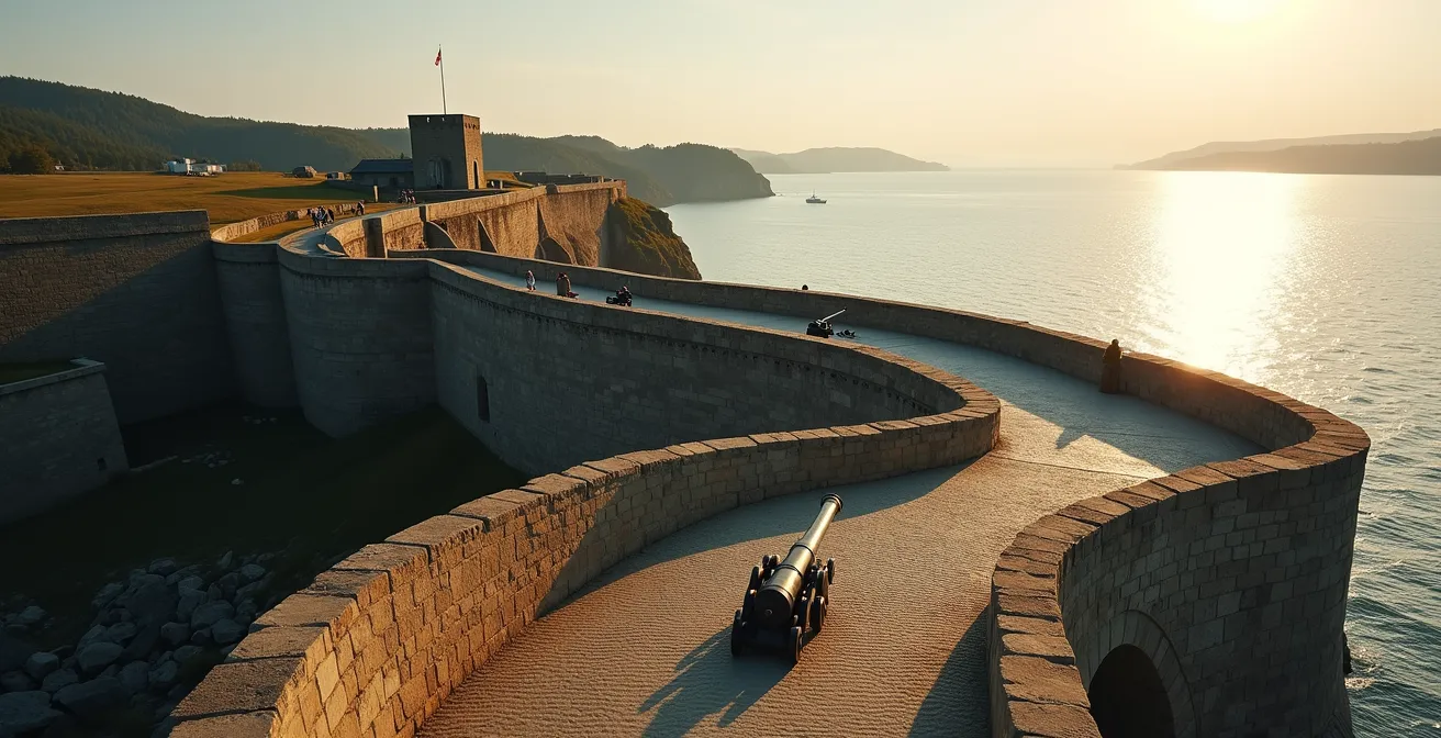
The selection of Cap Diamant was not a choice; it was a geostrategic imperative. From this height, the St. Lawrence River narrows dramatically, creating a natural chokepoint for all maritime traffic heading into the heart of the continent. To control this cliff was to control the gateway to New France. Samuel de Champlain, a man of military and cartographic genius, understood this with perfect clarity upon his arrival. His justification was devastatingly simple, as he noted in 1608 that from this vantage point, the river is no greater in width than the range of a cannon.
This single observation dictated the next 250 years of the city’s development. The cliff was a natural fortress, but its plateau, the future Upper Town, presented a significant vulnerability: the Plains of Abraham. This relatively flat expanse offered an enemy a platform to besiege the city. Military doctrine, therefore, demanded a man-made extension of the cliff’s defensive properties—the ramparts. The walls you see today are the direct answer to the problem of defending the landward side of this otherwise perfect fortress.
French military engineers were obsessed with this western flank. They knew an attack would likely come from there. To counter this, they not only built bastions but also engineered clever, hidden defenses. A prime example, as documented by Parks Canada, is the flank blockhouse of the glacis bastion, an underground battery from the 1750s. Built to surprise attackers on what was considered the weakest front, its subterranean cannons were designed to double the firepower on any force attempting to gain the heights. This wasn’t just building a wall; it was a layered, deadly trap designed to nullify the landscape’s single great weakness.
How to visit the Royal 22e Régiment base without interfering with official ceremonies?
The Citadelle of Quebec is not merely a museum; it is an active military base, home to the Royal 22e Régiment. Visiting requires a mindset of respectful observation, recognizing that you are a guest in a place of ongoing duty. The key to a meaningful visit without being disruptive is not to avoid ceremonies, but to understand their rhythm and position yourself as an informed spectator rather than a mere tourist.
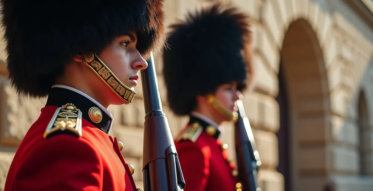
The most famous ceremony is the Changing of the Guard. Instead of rushing to the parade square at the last minute, the strategic visitor arrives early. The real moment for a historian is the pre-ceremony inspection, which takes place about 15-20 minutes before the main event. Here, away from the largest crowds, you can observe the meticulous inspection of the scarlet uniforms and the iconic bearskin caps. It’s a moment of quiet professionalism that offers a more authentic glimpse into military life than the grand parade that follows.
Positioning is also critical. Station yourself near the main barracks to witness the troops emerging and forming up. This provides a different perspective from the static view on the parade ground. Above all, be mindful of your surroundings. Do not cross roped-off areas, keep noise to a minimum, and follow any instructions given by soldiers or guides. Remember, these ceremonies are a living tradition, a “ceremonial echo” of the fortress’s centuries-old military purpose. By showing respect, you are not interfering; you are honouring that legacy.
Upper Town walls or Boardwalk: which route offers better historical context?
A history buff visiting Quebec City faces a crucial choice of path: the 4.6-kilometre walk atop the ramparts or the stroll along the Dufferin Terrace boardwalk. While both offer stunning views, they provide fundamentally different historical narratives. The ramparts offer a first-person perspective of the 18th-century soldier, while the boardwalk provides the scenic, detached view of a 19th-century citizen. The “better” route depends entirely on your objective: understanding the defensive system or enjoying the city’s picturesque landscape.
The Dufferin Terrace, for all its charm, is a later, civilian addition. As a detailed comparison of the two walks highlights, it was inaugurated in 1879 as part of a city beautification project. While it occupies a site where early cannon batteries once stood, its purpose is purely aesthetic and social. Walking its 425-metre length offers magnificent panoramas of the St. Lawrence and the Lower Town, but it places you outside the defensive perimeter, looking up at it.
| Feature | Upper Town Walls Walk | Dufferin Terrace Boardwalk |
|---|---|---|
| Historical Period | 18th-century military perspective (rebuilt 1745) | 19th-century civic promenade (inaugurated 1879) |
| Distance | 4.6 kilometres total | 425 metres long |
| Walking Time | Approximately 4 hours with historic sites | 30-45 minutes leisurely pace |
| Military Features | Cannons, bastions, gates, underground battery access | Views of fortifications from below |
| Best For | Understanding complete defensive system | Scenic river views and photography |
In contrast, walking the ramparts themselves is an exercise in applied military history. From this vantage point, you see the city as its defenders did. You understand the interlocking fields of fire from the bastions, the strategic placement of the gates, and the commanding view over any approaching force. It is from the walls that you can truly read the stone and grasp the logic of the entire system. For anyone wanting to understand the military context of New France, the choice is clear: the Dufferin Terrace is for a postcard view, but the ramparts are for historical immersion.
The reconstruction error people mistake for original 17th-century architecture
Many visitors look upon the ornate gates and picturesque towers of the fortifications and assume they are seeing the authentic work of French military engineers. This is a common misconception, a direct result of a 19th-century “reconstruction error”—or more accurately, a deliberate romanticization. The man responsible was Lord Dufferin, Governor General of Canada from 1872 to 1878. Faced with calls to demolish the aging, “useless” walls, Dufferin instead launched a campaign to preserve and beautify them, transforming them from a purely military structure into the romantic, touristic asset we see today.
His vision, inspired by the medieval townscapes of Europe, introduced elements that had no basis in 17th or 18th-century defensive doctrine. The most prominent example is the Kent Gate, built in 1878. It is a purely Victorian addition, designed for aesthetic appeal with its turrets and fairytale appearance, not for repelling cannonballs. He similarly modified the existing Saint-Louis and Saint-Jean gates, adding a picturesque flair that was entirely foreign to their original, brutally functional design. This was not a restoration; it was a rebranding.
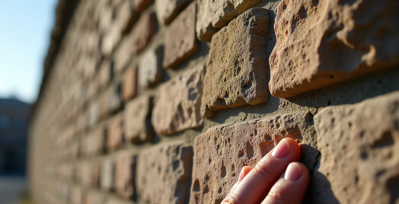
For the history buff, learning to distinguish between these periods is the ultimate act of “reading the stone.” It allows you to see past the romantic veneer to the authentic military structure beneath. The key is to look for the changes in masonry and style. The original French work is often rougher, more irregular, while the British improvements are more uniform. Dufferin’s Victorian additions are unmistakable in their decorative, non-functional character. By learning to spot these layers, you can deconstruct the wall’s history with your own eyes.
Your Action Plan: Spotting the Layers of History
- Observe the Masonry: Look for the rough, irregular limestone blocks typical of the early French-era construction (1693-1745).
- Identify British Sandstone: Note the more uniform, precise blocks of green sandstone, often from the Sillery area, used in British-era improvements and repairs.
- Spot Victorian Additions: Isolate purely decorative elements, like the turrets on the Kent Gate, which were added by Lord Dufferin in the 1870s for romantic appeal.
- Compare Gate Styles: Contrast the functional design of older sections with the heavily modified, picturesque appearance of the Saint-Louis Gate after its Victorian facelift.
- Question the Ornament: When you see a decorative carving or flourish, ask yourself: “Does this serve a defensive purpose?” If the answer is no, you are likely looking at a 19th-century addition.
When to arrive at the Citadelle to get a front-row view of the ceremony?
To secure a front-row view of the Changing of the Guard ceremony, you must think tactically. The ceremony takes place daily at 10 a.m. from late June through Labour Day, and arriving just on time guarantees a spot behind several rows of people. The optimal strategy is to arrive 15 to 20 minutes early. This allows you to witness the pre-ceremony inspection, a fascinating and less-crowded event in its own right, and to choose a prime viewing location along the edge of the parade square before the main crowds converge.
The ceremony itself is rich with unique traditions. It is the only one of its kind where the regimental mascot, Batisse the goat, participates alongside officers in full scarlet dress uniforms and bearskin hats. Beyond the Changing of the Guard, another key temporal event is the daily firing of the noon cannon. This tradition, continuing every day at noon since 1871, is a powerful auditory link to the fortress’s past, its boom echoing across the city as it has for over 150 years. Arriving before noon ensures you can witness this historical moment.
Ultimately, timing your arrival is about more than just getting a good photo. It’s about positioning yourself to appreciate the layers of the experience: the quiet discipline of the inspection, the pageantry of the parade, and the historical resonance of the cannon. A 20-minute head start transforms you from a passive audience member into an engaged observer of living history.
Why are the cliffs of PEI retreating by meters every year?
While Quebec’s fortress stands on unyielding Precambrian rock, other iconic Canadian landscapes tell a different story of geography and time. On Prince Edward Island, the famous red cliffs are a testament to impermanence. Unlike the hard gneiss of Cap Diamant, PEI’s cliffs are composed of soft, sedimentary sandstone. This material is highly susceptible to erosion from wind, rain, and, most powerfully, the relentless action of ocean waves.
Each winter, the freeze-thaw cycle expands cracks in the rock, weakening its structure. In the spring, storms and high tides carry away the loosened material at an astonishing rate. In some exposed areas, the coastline is retreating by several meters each year, a dramatic contrast to the stability of Quebec’s foundation. This process reveals a fundamental truth for the historian: the very geology of a place dictates its potential for preservation. Quebec’s story could be written in stone because the stone itself was permanent. PEI’s history, in a geological sense, is being constantly erased and rewritten by the sea.
This provides a valuable comparative context. The challenge in Quebec was to build a defense strong enough to withstand human enemies; the challenge in PEI is that the land itself is a transient feature. Understanding this helps one appreciate the sheer luck of geology that allowed Quebec’s man-made history to survive for so long.
The architectural quirk that makes Dawson’s buildings lean at odd angles
Journeying from the solid bedrock of Quebec to the far north of Dawson City, Yukon, reveals another profound relationship between architecture and environment. Here, the defining architectural quirk isn’t a design choice, but a geological inevitability: many historic buildings lean at peculiar angles, as if perpetually tipsy. This phenomenon is a direct result of building on permafrost—a layer of permanently frozen ground.
The original Klondike Gold Rush builders of the late 1890s constructed their buildings directly on this frozen soil. However, the heat from the buildings themselves, combined with minor climatic shifts, gradually thaws the upper layers of the permafrost. As the ice-rich soil thaws, it loses its structural integrity and settles unevenly. The result is “drunken buildings” that sink, twist, and lean, their foundations shifting on the unstable ground. The famous Downtown Hotel and the Kissing Buildings are prime examples of this process in action.
This provides a stark contrast to Quebec’s fortifications. In Quebec, engineers had to contend with the strategic challenges of a solid, predictable landscape. In Dawson, builders fought a constant, losing battle against a landscape that was actively trying to swallow their creations. It serves as another reminder that to understand a historical site, one must first understand the ground on which it stands—whether it’s the unyielding granite shield of the east or the shifting, frozen soil of the north.
Key Takeaways
- The fortifications of Quebec are a direct response to a single geostrategic reality: the St. Lawrence River narrows to the range of a cannon.
- What appears as “original” architecture is often a 19th-century romantic layer; the true military history lies in the plainer, more functional masonry.
- A site’s history is dictated by its geology, whether it’s the stable bedrock of Quebec, the eroding cliffs of PEI, or the melting permafrost of the Yukon.
How to navigate the language barrier in rural Quebec if you don’t speak French?
For the history buff venturing beyond the bilingual comfort of Old Quebec, navigating the language barrier in rural regions is not an obstacle, but an opportunity for deeper immersion. It requires a shift in mindset, from that of a consumer demanding service to that of a respectful guest. The approach can be framed as a form of strategic cultural navigation. Your goal is not just to get what you need, but to connect with the place on its own terms.
The single most powerful tool is effort. Attempting a few basic words in French—“Bonjour” (Hello), “S’il vous plaît” (Please), “Merci” (Thank you), “Excusez-moi” (Excuse me)—signals respect and goodwill. It communicates that you recognize you are in a distinct cultural space. This simple act can transform an interaction, often encouraging a local to switch to English if they are able, or at the very least, to be more patient and helpful.
Modern technology is your ally. A translation app on your phone can bridge any significant gaps, but it should be used as a support tool, not a primary interface. Show the person the screen, or speak into the app, but maintain eye contact and a friendly demeanor. Patience is paramount. Speak slowly and clearly in English, avoid slang, and be prepared to use gestures. More often than not, a combination of your few French words, their few English words, and universal hand signals will solve the problem. Approaching the language barrier not as a problem but as part of the authentic travel experience is the key to unlocking the warmth and history of rural Quebec.
Your visit to Quebec is more than a holiday; it’s a historical investigation. By learning to read the stone, observe its living traditions, and navigate its cultural landscape with respect, you transform a simple trip into a profound exploration. Start planning your own strategic discovery of Quebec’s past today.
Frequently Asked Questions about the Citadelle Ceremonies
What time does the Changing of the Guard ceremony take place?
The ceremony occurs daily at 10 a.m., running from June 24th until Labour Day in early September. As this is an outdoor ceremony, it can be cancelled in the event of very poor weather.
How early should I arrive for the best viewing position?
For the best, unobstructed views, it is highly recommended to arrive 15-20 minutes before the 10 a.m. start time. This allows you to watch the pre-ceremony inspection and secure a spot before the largest crowds arrive.
What unique elements make this ceremony special?
This is the only military ceremony of its kind that features the regimental mascot, a goat named Batisse. He participates in the parade alongside the soldiers of the Royal 22e Régiment, who are dressed in their traditional scarlet tunics and large bearskin hats.