Most travellers see the prairie drive as a flat, boring void to be endured. The truth is, it’s a subtle, living landscape waiting to be read. Instead of just surviving the drive, this guide teaches you how to decode the dramatic skies, the colours of the fields, and the stories on the horizon, transforming a monotonous journey into an immersive experience in Canadian geography and history.
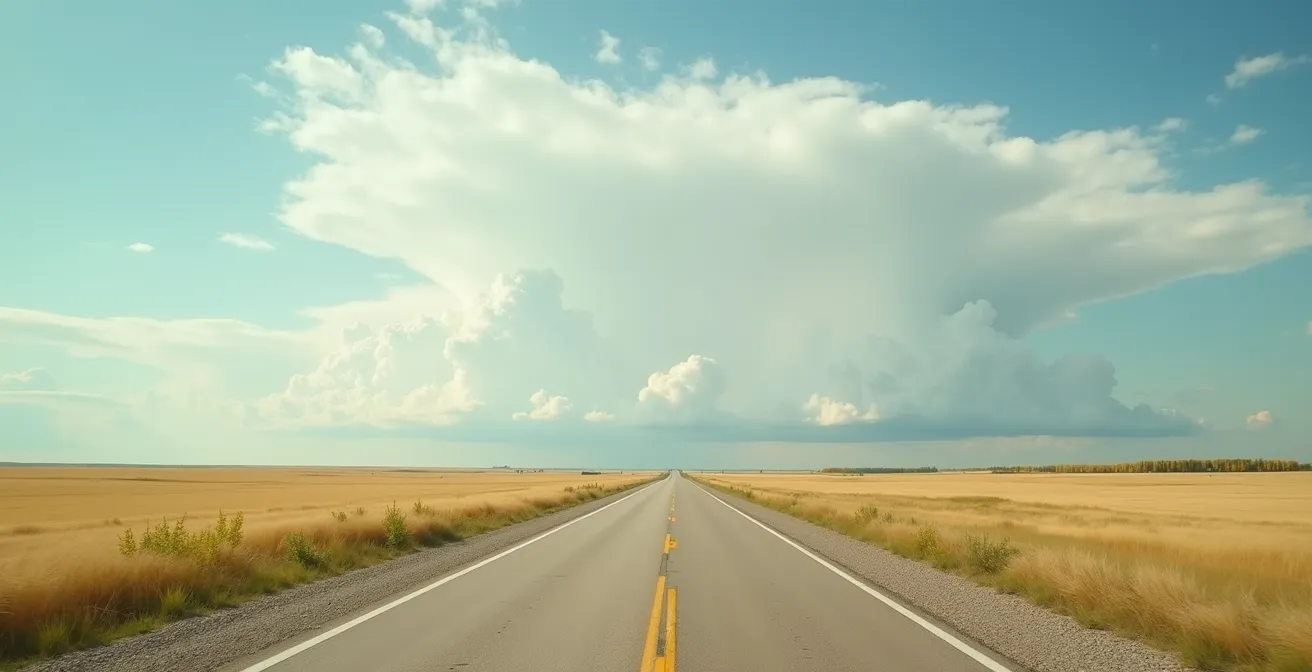
The Trans-Canada Highway cuts a straight, determined line across Saskatchewan, a stretch of pavement infamous among road trippers. The conventional wisdom is to put on a good playlist, stock up on snacks, and simply endure the 7-8 hours of perceived nothingness. Many fear the notorious “highway hypnosis” and the sheer, unending flatness. They focus on the destination, treating the journey as a necessary evil, and in doing so, they miss the entire point.
This perspective, while common, is a missed opportunity. The prairies are not empty; they are subtle. Their beauty doesn’t shout; it whispers in the language of towering storm clouds, fields of fluorescent canola, and the lonely silhouettes of disappearing grain elevators. To appreciate this drive is to shift your perspective from a passive driver to an active observer, a reader of the landscape.
But what if the key wasn’t to distract yourself from the drive, but to engage with it more deeply? This guide is built on that premise. We will move beyond the platitudes and teach you how to interpret the visual cues of the prairie. You will learn not just what you are looking at, but *why* it looks the way it does. We will explore the science of the sky, the economics of the fields, and the history held within the wooden sentinels that once defined this province. By the end, the long, straight road will no longer feel like an obstacle, but a gallery of immense scale and quiet grandeur.
This article will guide you through the layers of the prairie landscape, from its celestial dome to its cultural heart. Let’s begin the journey of transforming your perception of one of Canada’s most misunderstood drives.
Summary: A Driver’s Guide to the Soul of Saskatchewan
- Why are prairie sunsets and storm clouds more dramatic than anywhere else in Canada?
- Canola, wheat, or flax: how to tell what is growing in the yellow and blue fields?
- Why are the wooden grain elevators disappearing from the horizon?
- The “highway hypnosis” risk specific to 500km of straight road
- Where to stop for authentic pierogies in Manitoba’s small communities?
- Why does ‘highway hypnosis’ strike on the Prairie straightaways?
- Why does staying in rural inns keep small Canadian villages alive?
- How to plan fuel stops on the Trans-Canada Highway where stations are 200km apart?
Why are prairie sunsets and storm clouds more dramatic than anywhere else in Canada?
The first thing you notice on the prairies is the sky. It’s not just big; it’s an entire event, a celestial dome that puts on a daily performance. The reason for this unparalleled drama lies in a combination of topography and meteorology. With no mountains or significant hills to obstruct the view, you are witnessing the full 180-degree arc of the horizon. This vast, unbroken canvas allows light to behave in spectacular ways.
During sunrise and sunset, the sun’s rays travel through more of the Earth’s atmosphere to reach your eyes. This phenomenon, known as Rayleigh scattering, filters out blue light, allowing the vibrant reds, oranges, and purples to dominate. On the flat prairies, this effect is amplified, painting the entire sky with an intensity rarely seen in more varied terrain. Furthermore, the prairies are a battleground for weather systems. Cool, dry air from the Rockies clashes with warm, moist air from the south, creating the perfect conditions for powerful thunderstorms.
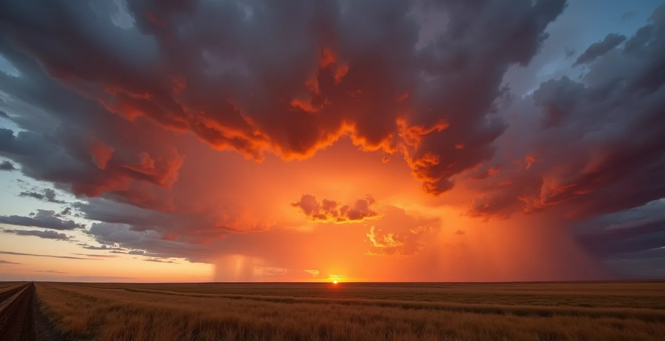
These storms build into towering structures, their anvil-shaped tops scraping the upper atmosphere. The most sought-after formations for a photographer are mammatus clouds, eerie pouch-like structures that hang beneath the storm’s anvil, often signaling severe weather. They catch the low-angle light of a setting sun, creating a three-dimensional, otherworldly spectacle. This is not just weather; it is a dynamic sculpture of light and moisture, a direct result of the unique prairie environment.
Your Action Plan: Prairie Sky Watching Guide
- Download Environment Canada’s weather radar app to track approaching storm systems for optimal viewing positions.
- Position yourself 30-60 minutes before sunset on the eastern edge of an approaching weather system for maximum colour intensity.
- Look for mammatus clouds (pouch-like formations) hanging from storm anvils—they indicate severe weather and create dramatic lighting.
- Scan for rare asperitas clouds (wave-like undulations) which appear most often over flat prairie terrain due to atmospheric instability.
- Find an elevated position, even a small hill or overpass, to maximize your 180-degree view of the celestial dome effect.
Instead of seeing an empty sky, you can learn to read it as a forecast and a spectacle, a reward for patient observation.
Canola, wheat, or flax: how to tell what is growing in the yellow and blue fields?
Once you pull your eyes from the sky, you’ll notice the ground is a patchwork of vibrant colour. These vast, monochromatic fields are not just scenery; they are the heart of Canada’s agricultural engine. Learning to identify them is like learning the economic language of the prairies. The brilliant, almost fluorescent yellow that dominates the landscape from June to July is canola. It’s an iconic prairie crop, and Canada is a world leader in its production. Statistics Canada reported that in 2024 alone, Canadian farmers produced 17.8 million tonnes of canola.
Interspersed with the yellow, you may see fields shimmering with a delicate, sky-blue hue. This is flax, a crop grown for its seeds (flaxseed) and oil. Unlike the bold carpet of canola, flax fields appear as gentle waves of colour, their five-petaled flowers often closing in the midday sun. The other dominant colours are the shades of gold and green from cereal grains like wheat and barley. While they lack colourful flowers, they can be distinguished by their “beards” or awns—the bristle-like fibres extending from the grain heads. Barley typically has much longer, more graceful beards than wheat.
This crop identification guide helps translate the colours of the prairie into a clear picture of its agricultural identity.
| Crop | Flower Color | Field Appearance | Bloom Period | Distinguishing Features |
|---|---|---|---|---|
| Canola | Brilliant Yellow | Fluorescent yellow carpet | June-July | Sweet honey scent, 4-petaled flowers |
| Flax | Sky Blue | Delicate blue waves | June-August | 5-petaled flowers, closes at night |
| Wheat | No flowers (grain heads) | Golden stalks | July-August | Short ‘beards’ (awns), rustling sound |
| Barley | No flowers (grain heads) | Light gold stalks | July-August | Long flowing ‘beards’ up to 6 inches |
| Alfalfa | Purple | Less uniform patches | June-September | Clustered flowers, cut multiple times |
Each field tells a story of the season, the soil, and the global economy, written in a palette of yellow, blue, and gold.
Why are the wooden grain elevators disappearing from the horizon?
For a century, the prairie skyline was defined by them: towering wooden grain elevators, affectionately known as “prairie sentinels.” Standing tall beside the railway tracks, every small town had at least one. Today, they are a rare sight, their slow disappearance marking a fundamental shift in the economic DNA of rural Canada. These structures weren’t just for storage; they were the commercial and social hubs of farming communities. They were the physical link between an individual farmer’s harvest and the vast national and international grain markets.
Their decline began with two major changes. First, the consolidation of railways and the rise of semi-truck logistics. Grain began to be trucked to massive, centralized concrete or steel terminals in larger centres, making the smaller, local wooden elevators obsolete. Second, the nature of farming itself changed. Small family farms were amalgamated into huge industrial operations, which had the capacity to store grain on-site or transport it directly to the large terminals. The old system, built for a different scale of agriculture, simply couldn’t compete.
As the authors of *Saskatchewan’s Best Scenic Drives* note, their loss is more than just architectural. As Robin and Arlene Karpan state:
Each elevator represented a community’s direct line to the national economy, a place where generations of farmers met and did business.
– Robin and Arlene Karpan, Saskatchewan’s Best Scenic Drives
Some communities, however, are fighting to save these icons. The preservation project in Indian Head, Saskatchewan, transformed its historic elevator into a living museum and film location. This initiative not only preserved a piece of prairie heritage but also created a new tourism draw, educating visitors on the very economic forces that led to the decline of these structures. Spotting a wooden elevator today is a glimpse into a bygone era, a reminder of the deep roots of agriculture in the prairie identity.
Each one you see is a survivor, a monument to a way of life that shaped the very landscape you are driving through.
The “highway hypnosis” risk specific to 500km of straight road
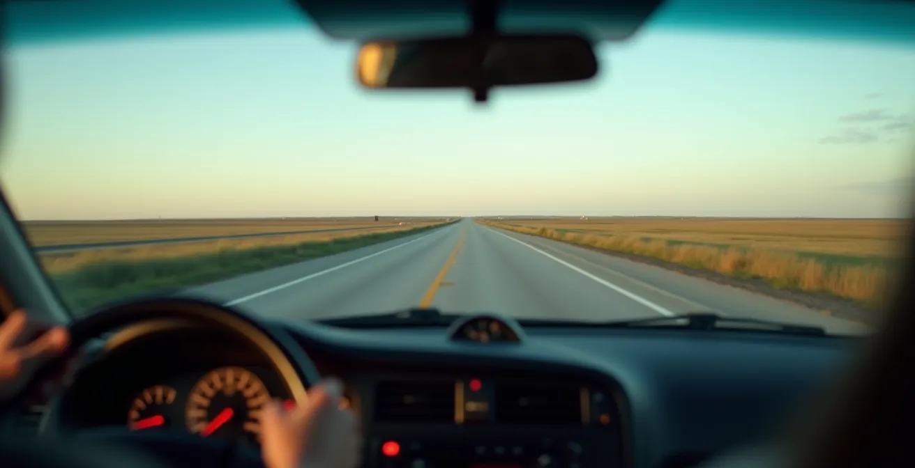
The long, straight stretches of the Trans-Canada Highway through Saskatchewan are infamous for inducing a dangerous, trance-like state known as “highway hypnosis.” This isn’t merely feeling tired; it’s a specific neurological phenomenon where the monotonous visual input—the endless straight road, the repetitive hum of the tires—causes a driver’s brain to enter a state of automaticity. You are still steering and controlling the car, but your conscious attention has disengaged. You might “wake up” to realize you can’t recall the last several kilometres driven. This creates a significant safety risk, as your reaction time to unexpected events, like wildlife on the road or a vehicle braking ahead, is severely delayed.
The danger is real and widespread. A survey from the Canadian Automobile Association (CAA) found that 18% of Canadian drivers admit to having driven when they were too tired to keep their eyes open. On the prairies, this risk is amplified by the sheer lack of stimuli. The road doesn’t curve, the scenery changes slowly, and the lack of traffic can lull you into a false sense of security.
The key to combating this is not caffeine, but active sensory engagement. Instead of zoning out, you must force your brain to process new information. This means consciously shifting your focus. Create a “Prairie Bingo” card with landmarks to find: a red-winged blackbird on a fencepost, a mile-long train, a ghost town, or a roadside memorial. Every hour, tune into a different local small-town radio station. The shift in music, news, and advertisements provides crucial auditory variety.
Most importantly, take mandatory breaks. Every 90 to 120 minutes, pull over at a rest stop or in a small town. Get out of the car, walk around, and reset your alertness system. This isn’t a sign of weakness; it’s a critical safety strategy for navigating the unique challenges of the prairie drive.
By turning observation into a conscious task, you not only stay safer but also begin to notice the subtle details you would otherwise miss.
Where to stop for authentic pierogies in Manitoba’s small communities?
While the title mentions Manitoba, the heart of this culinary quest beats strongly across the entire prairie region, especially in Saskatchewan, which is home to a deep and proud Ukrainian heritage. To find authentic pierogies (or *varenyky*, the traditional Ukrainian term), you must bypass the restaurants and look for the true source: church basement fundraisers. These are not commercial enterprises; they are community events that preserve culinary traditions passed down through generations while supporting local programs.
Finding them is part of the adventure. Look for handwritten signs on community bulletin boards at local Co-op grocery stores, gas stations, and town halls. These sales are often held on Saturday mornings, and the pierogies are typically sold by the dozen, frozen, and almost always require cash. Don’t be surprised to see line-ups; it’s not uncommon for locals and travelers alike to drive hundreds of kilometres for a taste of the real thing.
Case Study: The Canora Perogy Trail
In Canora, Saskatchewan, the Ukrainian Orthodox church’s monthly perogy sales are legendary. On the third Saturday of each month, a team of volunteers gathers before dawn to hand-pinch over 5,000 pierogies, using recipes that have been in their community for over a century. The proceeds support church maintenance and community programs. More importantly, the bulletin board at the church acts as an informal hub, connecting travelers to similar events in nearby towns and effectively creating a “perogy trail” that maps the patterns of Ukrainian settlement from the late 1890s.
Beyond pierogies, look for other signs of Eastern European culinary heritage. Local delis selling kubasa (garlic sausage), bakeries offering cabbage rolls, and farmers’ markets with poppy seed rolls are all indicators that you’ve found a town with strong Ukrainian or Polish roots. These foods are the flavour of the prairies, a delicious reward for slowing down and engaging with the small communities that are the backbone of the region.
Each bite is a taste of history, a direct connection to the homesteaders who settled this land and whose legacy endures in these cherished recipes.
Why does ‘highway hypnosis’ strike on the Prairie straightaways?
The phenomenon of “highway hypnosis” on a long, straight road is more than just simple boredom or fatigue; it’s a predictable neurological response to a lack of new stimuli. To understand it, you need to look at a part of your brain called the reticular activating system (RAS). The RAS acts as a filter, deciding what sensory information is important enough to bring to your conscious attention. When you’re driving in a complex urban environment, the RAS is highly active, processing a constant stream of new data: traffic lights, pedestrians, merging lanes, and road signs.
On a prairie straightaway, the opposite happens. The visual input is highly repetitive: the same grey ribbon of road disappearing into a fixed vanishing point, the same fields on either side, the same sky above. The auditory input is a monotonous drone from the engine and tires. With no new or surprising information to process, the RAS down-regulates. It essentially decides that nothing new is happening and that it can conserve energy. This induces the trance-like state of highway hypnosis, where your body performs the automated tasks of driving without conscious oversight. As the Cleveland Clinic explains, the brain’s reticular activating system down-regulates due to this lack of stimuli, inducing the trance. It’s not a character flaw; it’s brain mechanics.
This state can set in alarmingly fast. While it feels like it takes hours of driving, research has shown that signs of mental fatigue and disengagement can appear after as little as 20 minutes on a monotonous road. The brain is simply too efficient for its own good in these situations. It automates the task to free up mental resources, but on the highway, this automation is a liability. This is why active engagement—consciously looking for specific landmarks, changing the radio station, or talking to a passenger—is so effective. It forces the RAS to stay active by providing it with new, varied stimuli to process, keeping your conscious mind in the driver’s seat.
It reframes the problem from a simple matter of “staying awake” to a more complex challenge of “staying engaged.”
Why does staying in rural inns keep small Canadian villages alive?
When choosing where to spend the night on a prairie road trip, the decision between a chain hotel on the highway outskirts and a locally owned inn in a small town has profound economic consequences. Opting for the small, rural inn is a direct investment in the survival of that community, thanks to a principle called the economic multiplier effect. When you pay for a room at a chain hotel, a significant portion of that revenue—often up to 80%—is immediately funneled out of the community to a corporate headquarters in a distant city.
In contrast, when you stay at a local bed and breakfast or inn, your money stays and circulates within the town. The innkeeper uses your payment to buy groceries at the local Co-op, the Co-op clerk pays the local mechanic to fix their car, and the mechanic buys a coffee at the town’s cafe. That single payment from you can circulate five to seven times within the community, generating economic activity far greater than the initial cost of the room. This process is the lifeblood of small prairie towns, which often lack a diverse economic base.
The Multiplier in Action: Coronach, Saskatchewan
The Country Flavor Bed and Breakfast in Coronach, a small town in southern Saskatchewan, is a perfect example. A traveler’s $100 room payment can generate up to $700 in total local economic activity. By choosing to stay there, visitors are not just renting a bed; they are actively helping to pay local wages, support local shops, and fund community services through property taxes. This choice directly contributes to the town’s viability.
Furthermore, innkeepers are the oral historians and unofficial ambassadors of their communities. They can provide recommendations for hidden gems—the best local cafe, a scenic backroad, or an interesting historical site—that you would never find on a travel website. By booking directly with them (rather than through large online travel agencies that take a commission), you ensure that 100% of your money goes toward sustaining the very community you are there to experience. Your tourism dollars become a powerful tool for cultural and economic preservation.
It’s a small decision with a significant impact, ensuring these prairie towns continue to have stories to tell for future travelers.
Key Takeaways
- The “boring” prairie drive is a myth; its beauty lies in its subtlety and requires active observation to appreciate.
- The landscape is a readable text telling stories of meteorology, agriculture, economic history, and cultural heritage.
- Engaging with the drive by decoding the sky, fields, and towns is the best way to combat highway hypnosis and enrich your journey.
How to plan fuel stops on the Trans-Canada Highway where stations are 200km apart?
The vastness of the Saskatchewan prairies is not an exaggeration, and this is most apparent when it comes to fuel. On certain stretches of the Trans-Canada Highway, particularly between major towns like Moose Jaw and Swift Current, gas stations can be separated by distances of up to 200 kilometres. Running out of fuel here is not a minor inconvenience; it can be a serious situation, especially in extreme weather or after dark. Meticulous fuel planning is not optional; it is a fundamental part of a safe and stress-free prairie road trip.
The most effective strategy is the “Half-Tank Rule.” It’s simple: the moment your fuel gauge hits the 50% mark, you should begin actively looking for a gas station in the next town. Do not wait until the fuel light comes on. This rule builds in a generous buffer, completely eliminating range anxiety and preventing you from being forced to rely on a single, isolated station that might be closed. Many rural gas stations are not 24/7 operations and can close as early as 6 PM. While apps like GasBuddy are useful, it’s always wise to call a station ahead if you plan on arriving late.
Another crucial tip is to be aware of “cardlock” stations. These are common in rural areas and are intended for commercial trucking fleets, requiring a special fleet card for payment. They will not accept standard credit or debit cards, so avoid pulling into a station that is clearly marked for commercial use only. Finally, never rely solely on your phone’s GPS. Cell service can be patchy or non-existent between communities. A simple, paper provincial highway map is an invaluable backup, as it marks every town and settlement, ensuring you always know where the next potential stop is.
You can even turn this practical necessity into part of the adventure. Plan your stops to coincide with some of Saskatchewan’s quirky roadside attractions, like the giant coffee pot in Davidson or Mac the Moose in Moose Jaw. This “Fuel & Find” approach makes a mandatory stop a fun break.
With a full tank and a solid plan, you are free to focus on the subtle beauty of the landscape around you.
Frequently Asked Questions about Driving the Prairies
How do I find authentic church basement perogy sales versus restaurant versions?
Look for handwritten signs on community boards at gas stations, Co-ops, and town halls. Church sales typically happen on Saturdays, sell by the dozen, and require cash payment.
What other Eastern European foods indicate a town’s heritage?
Search for kubasa (garlic sausage) at local delis, cabbage rolls at bakeries, and poppy seed rolls at farmers’ markets – these items signal strong Ukrainian or Polish communities.
Why is Glendon, Alberta called the ‘Perogy Capital of the World’?
Glendon erected a 27-foot tall perogy statue in 1993 and hosts an annual Perogy Festival celebrating the region’s Ukrainian heritage, drawing thousands of visitors each August.